 |
|
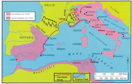
Map of the Invasion
Route and subsequent battle sites. The Roman Republic and Carthaginian
Empire at the start of the Second Punic War, 218 BC. The route followed
by Hannibal from New Carthage to the lower Rhône and across
the Alps is shown in red. While Hannibal’s exact route through
the Alps is subject to uncertainty, the most direct approach is along
the Rhône to the Drôme River and around to the north of
Mt. Viso, across the Col de la Traversette, to the Po River Valley
in northern Italia. Scipio’s advance on Massilia (Marseilles)
by sea and subsequent retreat to Pisa is traced with double arrows.
The site of the Trebbia Battlefield is located just east of the Ticinus
River. Lake Trasimene and Cannae are shown with double circles. Adapted
from M. Healy, Cannae 216 BC, Campaign Series, D.G. Chandler (Ed.),
Osprey Publishing Ltd, Oxford, U.K., 1999, and plate one in The Warmaker,
published by IUniverse 2008. |
|
| |
|
| |
|
|
 |
|
|
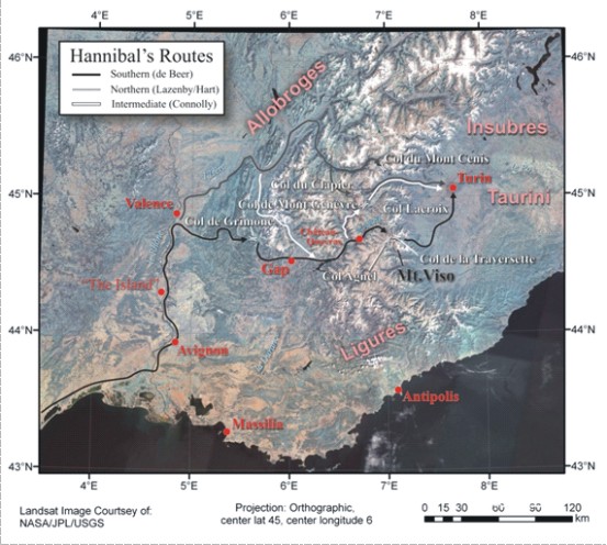
| Satellite image of the Western
Alps and Rhône Basin showing various proposed invasion routes
into Italia. Environmental evidence favors the southern route from
the Rhône to the Durance Basin, thence through the Queyras north
of Mt. Viso to the Upper Po River. For expanded text see W.C. Mahaney,
2008, “Hannibal’s Odyssey: Environmental Background to
the Alpine Invasion of Italia. Gorgias Press, Piscataway, NJ., 221
pp. |
|
| |
|
| |
|
|
|
|