 |
| Site navigation |
| Home |
| About the Author |
| The Warmaker |
| Hannibal's Odyssey |
| The Golden Till |
| Reviews |
| Articles |
| Maps |
| Other Works |
|
Correlative Web Sites |
| Quaternary Surveys |
| Research |
| Contact Us |
| Articles |
|
Feature Hannibal and The Alps: unravelling the invasion route W.C. Mahaney1, Barbara Kapran1 & Pierre Tricart2 1 Geography Department, 4700 Keele St, North York,
Ontario, Canada, M3J1P3 Over the last two millennia all the proposed invasion routes followed by the Punic Army in 218 BC have been based on historical and topographic analysis provided by Polybius and Livy, the two main ancient sources. Because Polybius actually followed the invasion route 60 years after the trek he is considered the prime authority. Livy never left his residence in Padua and studied the invasion from sources no longer available to us. Neither source provides a name for the approach route and ultimate col of transit into Italia but Polybius does state the col is the highest in the Alps—tas huperbolas tas anõtatõ. Several other ancient authors including Varro, Servius and Strabo list the cols from south to north as Col de Larche, Hannibal’s Pass, Col de Montgenèvre and Col de Mt Cenis, thus limiting Hannibal’s Pass to one of the three major cols south of the Col de Montgenèvre, which are from south to north, Col Agnel, Col de la Traversette and Col de la Croix. Invoking available geological and environmental evidence tied to descriptions in the ancient literature it is apparent Hannibal, either by design or happenstance, approached the Alps through the Queyras, the ultimate col of passage being the Col de la Traversette at nearly 3000 m above sea level. The implications of this find for geoarchaeology are enormous and offer the opportunity to find artefacts that will undoubtedly offer new insights into the military culture of ancient Carthage. One of the most controversial questions in ancient
history centres on the invasion route followed by the Punic Army
in one of the most daring military enterprises of all time, the
invasion of Italia in 218 BC. The invasion itself is important because
it opened a northern front in what promised to be a series of land
battles at low elevation in North Africa, or Iberia—no one
expected a Carthaginian attack from the northern frontier of the
Roman Republic. Establishing the exact route—north, intermediate,
south—followed by the Punic Army (see Figs 1A,B), whilst of
importance to historians, is of greater significance to archaeologists
as it offers the prospect of identifying key sites that might be
excavated to discover artefacts that might yield important new information
on the military culture of ancient Carthage. Conflicting interpretations
of Polybius and Livy have been presented and discussed by numerous
researchers over the years including such luminaries as Edward Gibbon
(1814), and Napoléon (de Montholon, 1905); and eminent military
historians including Dodge (1891), Hart (1967), Lazenby (1978),
General Sir Nigel Bagnall (1999), Goldsworthy (2001) and Sir Gavin
de Beer (1967, 1969). Aside from analysis of topographic features
and arguable interpretations of what Polybius actually meant by
several passages in his The Rise of the Roman Empire, only de Beer
attempted to invoke analysis of natural history, principally river
flow data to argue for a southern route through the Queyras and
over the Col de la Traversette into the upper Po River catchment.
Yet geology and especially geomorphology/pedology offer the possibility
of reconstructing the invasion route and identifying particular
sites of interest to geoarchaeologists. FEATURE
Mahaney, William C., Christopher C.R. Allen, Prasanna Pentlavalli, Anna Kulakova, Jonathan M. Young, Randy W. Dirszowsky, Allen West, Brian Kelleher, Sean Jordan, Coren Pulleyblank, Shane O’Reilly, Brian T. Murphy, Katrin Lasberg, Peeter Somelar, Michelle Garneau, Sarah A. Finkelstein, Magdalena K. Sobol, Volli Kalm, Pedro J.M. Costa, Ronald G.V. Hancock, Kris M. Hart, Pierre Tricart, René W. Barendregt, Ted E. Bunch, Michael W. Milner, 2016a. Biostratigraphic Evidence relating to the Age-Old Question of Hannibal’s Invasion of Italy: I, History and Geological Reconstruction, Archaeometry, v. 59, p.164-178, 2017. Mahaney, William C., Christopher C.R. Allen, Prasanna
Pentlavalli, Anna Kulakova, Jonathan M. Young, Randy W. Dirszowsky,
Allen West, Brian Kelleher, Sean Jordan, Coren Pulleyblank, Shane
O’Reilly, Brian T. Murphy, Katrin Lasberg, Peeter Somelar, Mahaney, W.C., Somelar, P., Pulleyblank, C., Tricart, P., West, A., Young, J., and Allen, C.C.R., Notes on magnetic susceptibility in the Guil valley alluvial mire correlated with the Punic Invasion of Italia in 218 BC. Mediterranean Journal of Archaeometry and Archaeology, v. 17, no. 1, p. 23-35, 2017. Mahaney, W.C., Somelar, P., West, Allen, Dirszowsky, R., Allen, C.C.R., Remmel, T., Tricart, P., Reconnaissance of the Hannibalic Route in the Upper Po Valley, Italy: Correlation with Biostratigraphic Historical Archaeological Evidence in the Upper Guil Valley of France. Archaeometry.
2018 Young, Jonathan M., Timofey Skvortsov, Brian P. Kelleher, William C. Mahaney, Peeter Somelar, Christopher C.R. Allen. Effect of soil horizon stratigraphy on the microbial ecology of alpine paleosols. Journal of the Total Environment, V. 657, p. 1183-1193. Mahaney, W.C., The Hannibal Route Question of 218 BC: a Forensic Exercise Relative to Historical Archaeology. Journal of Mediterranean Archaeometry and Archaeology, V. 18, No 3, pp. 45-62. 2020 Mahaney, W.C., The Hannibal Enigma of 218 BC: A Forensic Exercise of Importance to Historical archaeology. Scientific Culture. 6 (3), 7-24. Mahaney, W.C., The Hannibal Enigma. Desperta Ferro Ancient and Medieval History (in Spanish), 20-23. 2022 Mahaney, W.C., Somelar, P., Allen, C., Late Pleistocene Glacial-Paleosol-Cosmic Record of the Viso Massif—France and Italia—New Evidence in Support of the Younger Dryas Boundary (12.8 ka), International Journal of Earth Science, doi.org/10.1007/s00531-022-02243-9. 2023 Mahaney, W.C., The Younger Dryas Boundary (YDB): Terrestrial, Cosmic, or Both? International Journal of Earth Science, doi.org/10.1007/s00531-022-02287-x Fink, W., Vashna, V., Hare, T., Tricart, P., Mahaney, W.C., Hannibal’s misconstrued route across the alps reconstructed with Djikstra multi-objective optimal path planning, Nature, in progress. www.billmahaney.com |
||||
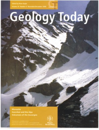
| Cover from Geology Today, Dec, 2008, showing the exfiltration trail out of the Col de la Traversette. The trail lower right leads around a bedrock bar and switchbacks down into the Upper Po River Valley where Hannibal regrouped after clearing a way through the two-tier rockfall described by Polybius (see Mahaney, ‘Hannibal’s Odyssey’, 2008). | |||||